Description
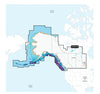
GARMIN CARTOGRAPHY 010-C1485-00 Compatible With Garmin GPS Navigation Systems/ Chart Plotters; Detailed Coverage Of Canada West And Alaska Lakes Rivers And Coastal; Region Code: NVUS013R; On SD/Micro-SD Card; One-Year Subscription; With Auto Guidance Technology High-Resolution Relief Shading High-Resolution Satellite Imagery Aerial Photography 3D Fisheye View 3D Mariner Eye View And Dynamic Lake Level
Brand : GARMIN CARTOGRAPHY
ManufacturerPart : 010-C1485-00
UPC : 753759334901
Length : 5.8 inches
Width : 4.1 inches
Height : 0.9 inches
Weight : 0.13 lbs
Case Quantity : 1
Prop65 Toxicity : B
Compatible With Garmin GPS Navigation Systems/ Chart Plotters; Detailed Coverage Of Canada West And Alaska Lakes Rivers And Coastal; Region Code: NVUS013R; On SD/Micro-SD Card; One-Year Subscription; With Auto Guidance Technology High-Resolution Relief Shading High-Resolution Satellite Imagery Aerial Photography 3D Fisheye View 3D Mariner Eye View And Dynamic Lake Level