Description
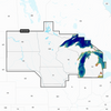
GARMIN CARTOGRAPHY 010-C1289-00 Compatible With Chart Plotters; Detailed Coverage Of Lakes And Rivers Of Iowa Michigan Minnesota North fits Dakota South Dakota Wisconsin And The US Waters Of The Great Lakes That Border Those States; Region Code: NVUS005R; On SD/ Micro-SD Card; With Auto Guidance Technology High-Resolution Relief Shading Sonar Imagery High-Resolution Satellite Imagery Aerial Photography Side-Scan Images 3D Fisheye View 3D Marinereye View And Dynamic Lake Level
Brand : GARMIN CARTOGRAPHY
ManufacturerPart : 010-C1289-00
UPC : 753759290634
Length : 5.8 inches
Width : 4.1 inches
Height : 0.9 inches
Weight : 0.13 lbs
Case Quantity : 1
Prop65 Toxicity : C
Compatible With Chart Plotters; Detailed Coverage Of Lakes And Rivers Of Iowa Michigan Minnesota North fits Dakota South Dakota Wisconsin And The US Waters Of The Great Lakes That Border Those States; Region Code: NVUS005R; On SD/ Micro-SD Card; With Auto Guidance Technology High-Resolution Relief Shading Sonar Imagery High-Resolution Satellite Imagery Aerial Photography Side-Scan Images 3D Fisheye View 3D Marinereye View And Dynamic Lake Level