Description
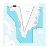
GARMIN CARTOGRAPHY 010-C1259-20 Compatible With Garmin GPS Navigation Systems/ Chart Plotters; Detailed Coverage Of Coast Of Greenland; Region Code: NSEU064R; On SD/Micro-SD Card; With Auto Guidance Technology High-Resolution Relief Shading High-Resolution Satellite Imagery Aerial Photography 3D Fisheye View 3D Mariner Eye View And Dynamic Lake Level
Brand : GARMIN CARTOGRAPHY
ManufacturerPart : 010-C1259-20
UPC : 753759289539
Length : 0.95 inches
Width : 0.95 inches
Height : 0.08 inches
Weight : 0.05 lbs
Case Quantity : 1
Prop65 Toxicity : C
Compatible With Garmin GPS Navigation Systems/ Chart Plotters; Detailed Coverage Of Coast Of Greenland; Region Code: NSEU064R; On SD/Micro-SD Card; With Auto Guidance Technology High-Resolution Relief Shading High-Resolution Satellite Imagery Aerial Photography 3D Fisheye View 3D Mariner Eye View And Dynamic Lake Level