Description
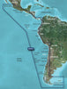
GARMIN CARTOGRAPHY 010-C1063-20 Compatible With Chart Plotters; Region Code: HXSA002R; Detailed Coverage Of West Coast Of Central And South America From Acalpulco Mexico To Tierra Del Fuego And Then North To Puerto Deseado Argentina; On SD/Micro-SD Card; With Integrated Garmin/Navionics Content Auto-Guidance Depth Range Shading Detailed Contours And Shallow Water Shading
Brand : GARMIN CARTOGRAPHY
ManufacturerPart : 010-C1063-20
UPC : 753759974336
Length : 8 inches
Width : 6 inches
Height : 1.5 inches
Weight : 0.5 lbs
Case Quantity : 1
Prop65 Toxicity : C
Compatible With Chart Plotters; Region Code: HXSA002R; Detailed Coverage Of West Coast Of Central And South America From Acalpulco Mexico To Tierra Del Fuego And Then North To Puerto Deseado Argentina; On SD/Micro-SD Card; With Integrated Garmin/Navionics Content Auto-Guidance Depth Range Shading Detailed Contours And Shallow Water Shading